CityLimits: As Flooding Becomes the Norm, City Island Residents Take Reins on Resiliency
In The NewsNine years after Superstorm Sandy flooded homes and tore the neon lobster from the town’s iconic Lobster House, residents see lack of city intervention as an opportunity.

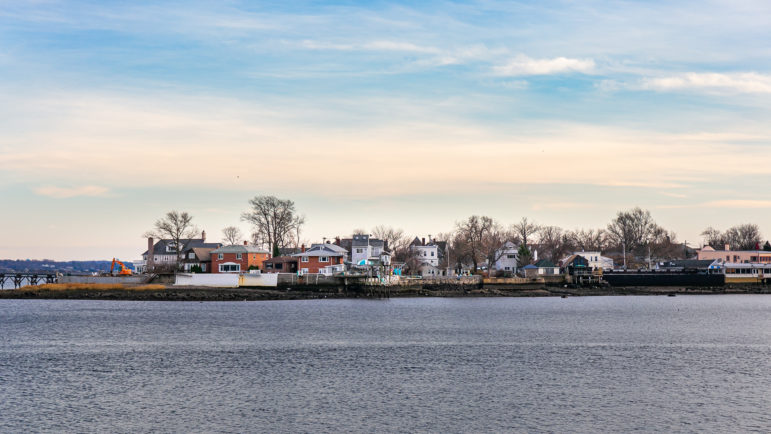
Adi Talwar,An evening view of the northern tip of City Island.
Several times a month, whenever there is a new moon or it rains more than a drizzle, the front of Victor Desantis’s City Island home becomes a lake.
Situated on the edge of a street that abruptly ends at marshes leading to the Eastchester Bay, and separated only by a short concrete rectangle block, Desantis’s property frequently floods — and it’s likely to only get worse.
His address has about an 85 percent chance of a flood over 14 feet before 2050, according to Climate Risk, a website that analyzes the likeliness of various climate-related hazards at a certain property. It also graded it with the highest-possible flood risk, calling it “extreme.”
This street is one of many, though, on City Island that regularly collects water even after the slightest weather events, according to John Doyle, of City Island Rising, a community-run nonprofit.
“This is not a once-a-season problem, this is a Tuesday problem,” he said.
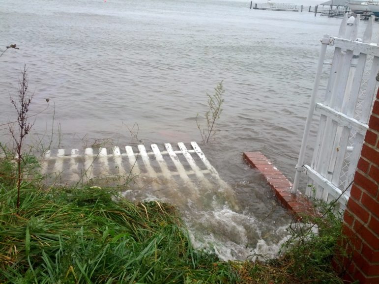
In 2012, Superstorm Sandy tore through the Bronx island, blowing off the neon lobster sign attached to the iconic Lobster House restaurant and causing extensive damage to properties, businesses and land. “People were literally clearing out the stuff in their living rooms because the whole living rooms flooded, like just bringing it up to the street,” Doyle said. But in his mind, the storm could have been much worse.
“If the tides had went the other direction, we would have been decimated,” he said.
The recent report by the Intergovernmental Panel of Climate Change warned of increased likelihood and intensity of so-called 100-year storms in the near future. For urban island communities like City Island already coping with flooding from minor rain events, the next big storm could be devastating. But locals say they’ve gotten little help from the city and state in addressing the island’s infrastructure and resiliency problems.
For example, the roads in Pelham Bay Park, along the evacuation route from the island, regularly flood, Doyle said. But his complaints to the city’s Department of Transportation have not resulted in significant fixes—“few and far between,” he said—instead, they refer him to the Parks Department and the Department of Environment Protection. He also shared a chain of unanswered emails sent to the Governor’s Office of Storm Recovery.
“It’s like a circular firing squad,” said Doyle. “There’s no one forcing these agencies to work together, to work in a holistic way to address some of these problems.”
Doyle, who grew up on the island and lives only blocks from his parents’ home, said he’s seen conditions in the neighborhood worsen throughout his lifetime — and not only for reasons related to climate change. Growing up, he lived next door to a fisherman; now, the island’s fishing economy is a relic of the past. Instead, the water surrounding the island is polluted with everything from illegal dumping in a nearby town to sewage issues to lead bullets from the NYPD’s nearby Rodman’s Neck Outdoor Range.
“We have some of the worst water quality in this section of the Long Island Sound,” said Doyle.
Frustrated with slow government efforts, the island’s residents have begun taking matters into their own hands in recent years, participating in data collection related to flooding and launching a mitigation effort with oysters.
Documenting the floods
Over the past few years, Doyle and other community members have taken nearly 1,000 photos of flooded streets and parks and submitted them to coastal resilience specialist Katie Graziano, of New York Sea Grant in partnership with the Science and Resilience Institute at Jamaica Bay.
Graziano collects the photos as part of a Community Flood Watch project, which involves community members to collect evidence of flooding as a way to create a hyperlocal database that is shared with the Mayor’s Office of Climate Resiliency.
“We want to make sure that they have access to information coming from the ground so that they really know how it’s affecting people and where, exactly, it’s affecting people,” Graziano told City Limits. “And then their role essentially is to integrate that into the thinking and the planning of the city.”
In the three years since she’s been collecting photos — from City Island as well as Hamilton Beach, Rockaway Peninsula and Coney Island — Graziano said she’s noticed not only a shift in general interest in flooding from the mayor’s office but also interest in flash flooding. In September, unexpected flash flooding from Hurricane Ida affected non-coastal areas of the city, leading to more than a dozen deaths in the city alone.
“I think the biggest thing is just how many people in New York City live with chronic flooding, and how much it affects their daily lives and how unheard of that is,” said Graziano.
A representative with the mayor’s office said that the information gathered through the program inspired the need for a pilot flood sensor project called FloodNet. This program, Graziano explained, uses software to further collect data in predetermined high-flood areas. The sensors are more hyper-specific than photos, she explained, so are able to finish the job of data collection after community members help with the legwork of identifying where flooding is most disruptive.
So far, the mayor’s office said, there are 10 sensors around the city, but none on City Island, though Graziano says the island is a “top priority” to receive some in the future—an additional 20 sensors are ready to be deployed, with their exact locations yet to be determined.
“Gowanus, Brooklyn and Hamilton Beach, Queens, are FloodNet’s two testbed neighborhoods and have been recording flood events since their installation in 2020, including significant flash flooding that occurred during Tropical Storm Henri and post-Hurricane Ida in 2021,” the spokesperson said.
The program is similar in theory to another ongoing research project conducted by Columbia University’s Earth Institute and funded by the National Oceanic and Atmospheric Administration (NOAA) for which New Yorkers help scientists collect data related to heat islands, particularly in communities of color.
Enabling residents to be involved in the data collection as active participants in inspiring policy change is key to the Flood Watch Project, too.
“We want the decision making to be based on sound science, and we want communities to use hard evidence to advocate for themselves,” said Graziano.

Courtesy John Doyle,Flooding on City Island during Hurricane Sandy in 2012.
The island is their oyster
While resiliency measures resulting from the data and additional efforts by City Island Rising are slow to be implemented, other residents are taking part in a project to naturally mitigate flooding and improve water quality and biodiversity on the island.
Started in winter 2019, the City Island Oyster Reef project is an effort to restore oyster reefs around the island, a natural method of filtering water, preventing shore erosion and lessening flooding.
Participants, who span generations and political viewpoints, follow guidance established by the state’s Department of Environment Conservation and the Billion Oyster Project, a citywide initiative to restore oyster reefs around New York’s waters.
“It cuts across classes and divisions and pulls people together who wouldn’t normally be pulled together,” said member Barbara Zahm.
The members collect oyster shells from local restaurants, after which the shells are cured for a year. They also conduct beach surveys and biodiversity studies and monitor the growth of oysters in cages, called Oyster Research Stations. The local public school science teacher has even incorporated education about oysters into her curriculum, Zahm said.
Oysters have rich history on the island — in the 1800s, oystering was a lucrative industry, and nearly 100 families on City Island made a living fishing them, according to the City Island Historical Society. Since then, however, as is the case in many similar coastal areas around the country, the population of oysters has declined significantly.
But like many resiliency efforts, the effects of the project will take time to be seen; It requires several years of training and research before the reefs can be installed.
In October, City Island Rising held a climate rally asking elected officials to recognize the urgency of the climate crisis and address flooding and other environmental issues on the island with immediate action, namely by passing the Climate and Community Investment Act (CCIA), which would fine major polluters and funnel the funds into local communities.
“It’s blatantly obvious we’ve come to the time that we’ve got to do something,” State Assembly Member Michael Benedetto, who attended the rally, told City Limits. That “something” includes passing the CCIA, he added, expressing optimism that recent weather events and warnings from scientists have caught the attention of legislators. “Hope will prevail,” he said.
In the meantime, Doyle feels resiliency projects are moving slower than the effects of climate change are being felt.
“Almost 10 years after Sandy… are we any better prepared or better off? I mean, we’re trying,” he said. “But I wouldn’t say we’re there yet.”
Liz Donovan is a Report for America corps member.

